Mt. St. Helens - Day 1
 The road into Mt. St. Helens from I-5 has three main Visitor Centers and a couple other learning centers too. At the first VC, Mark and I peruse the informative museum and see the 25-minute movie about the May 18, 1980 eruption. When we leave the VC, I stand to hear a ranger program while Mark buys us water from a kiosk there. On our way this morning, I wanted him to stop in south Washington at a market so we could load up on groceries, but he wanted to get to the mountain.
From the ranger I learn that Mt. St. Helens is the first and so far the only mountain that has erupted laterally. It quite surprised geologists, who thought volcanoes could only erupt out their tops. The ranger shows us a rock about the size of a T-bone steak that the eruption blasted 17 miles traveling at a speed of 670 mph! The eruption obliterated the top 1300 feet of the mountain and flattened 229 square miles of forest. We learn that Mt. St. Helens is continuously active today, billowing up molten lava at a rate of a dump-truck load every five to ten seconds. At that rate, the mountain will rebuild to its pre-eruption mass in about 40 years.
The VC was constructed to give a good view of the mountain, yet our view today is obstructed by ash—from the eruption 26 years ago—blowing around. It is a rare high wind day. People with trailers are warned not to go to the top because winds are recorded at 75 mph. Rangers who have been at the park for years have never experienced these high winds before. Further on up, a ranger at another VC tells us that the high winds sometimes occur in January, but this is the first summer high wind he knows of.
We ask that same ranger for some hiking suggestions, telling him we’d like hikes of four miles or less. He suggests three trails.
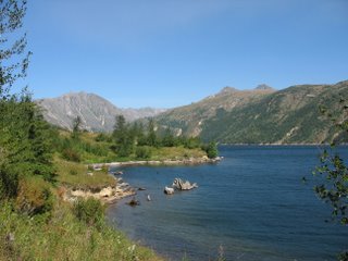 Right up the road from that center is the trailhead for the easy hike along Clearwater Lake, which was formed after the eruption dammed a stream. True to its name, the lake’s waters are clear and so blue. A large boulder sits in the middle, and timber lines the edges of the lake, all resulting from the eruption. We see a carcass on the trail, guessing that it used to be an elk.
Just a quarter mile up the road is the Hummocks trailhead. We are not particularly interested in seeing the hummocks, or small hills, that resulted from the eruption: we know what hills look like. Yet we want to give the wind time to die down so that we can hike up top, around the mountain. The ranger told us there was a dangerously narrow strip of rock to traverse there. I’m always up for thrilling.
The Hummock trail is moderate, but we make it strenuous as daylight is running out, and we are anticipating the final hike. In the car on the way to the last VC and the trail around Mt. St. Helens, I realize I pushed myself too far on the last trail; my legs are shaky. Wind is significantly less than what it had been earlier in the day, but gusts are still fairly strong we notice when we get out of the car at 4:55 p.m. in time to tour the VC before its 6 p.m. closing.
From the patio outside the VC through the yet ashy air, we can barely see the mountain’s current volcanic activity: the lava oozing out of a single point to the right of the caldera, like foam pouring over the sides of a beaker during a chemistry experiment gone bad. Inside the VC, Mark looks at the displays while I listen to a ranger program. He gives the same information I got from the other program upon entering the park. The unique display in that final VC concerns animals and how or if they survived the eruption. Some insects survived; few fished survived; nothing else did. But of course in the 26 years since, all species have made the mountain their home again.
We decide since we have no snacks, it is still a bit windy, the day is late, my legs are fatigued, and the trail is slightly dangerous, we will skip the hike around the mountain. So we give it one last look—majestic though reddish brown ash from the day’s winds covered the snow—before we drive out.
I-5 leads us to Kelso, where we have reservations at a chain motel. We are exhausted, not looking forward to going out again to dinner after cleaning up. If we had any food at all, we would be satisfied with a granola bar and some baby carrots. However, we don’t have any food. Luckily, in the same little business area as our motel is a grocery. Before checking in, we stop for SunChips, cheese, fruit and such. The store is big enough to have a deli so we buy sandwiches to take back to the room—so we can fall into bed after cleaning up. In addition, Mark buys two 40-ounces (beers) for himself— as I’m not a big drinker.
In our room we bring in our bags of luggage and food and transfer things to our soft-sided cooler, and Mark asks me if I’ve seen his 40-ounces. I haven’t. Turns out, he has to go back out after all.
I drop into bed, dead (until 5 a.m., when I woke up to take my basal body temperature. See first two blog entries for September.) Mark likely went to sleep soon after finishing his beer.
posted by Elizabeth Evans Fryer at 11:07 AM
![]()


0 Comments:
Post a Comment
<< Home