Thursday, October 26, 2006

Up the Oregon Coast - Last Day


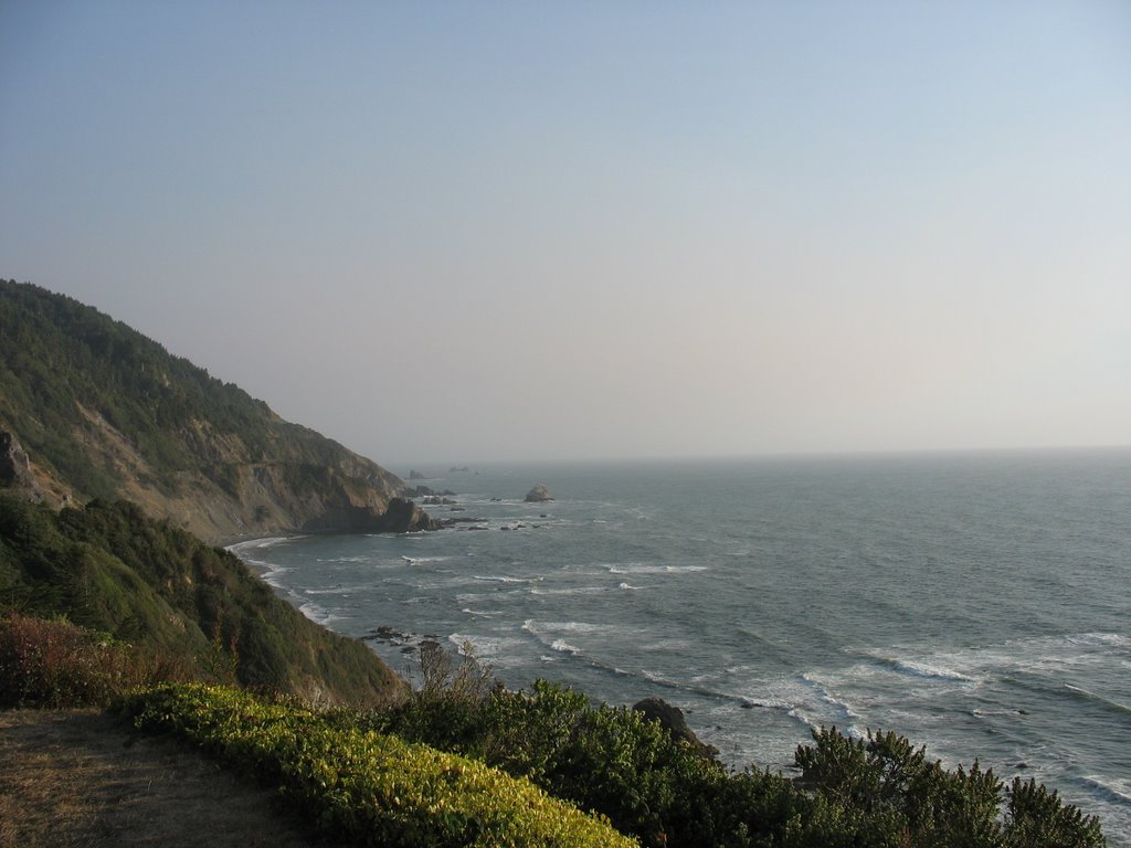
We are looking forward to this, our final full day in OR, not because it’s our last day but because we are looking forward to the stunning views as we drive up the coast. But the coast is covered in fog and is so until past 11 a.m. Quite the bummer.

We stop in a small town around 9 a.m. and walk out on the public dock and see the sea lions waking. Two ambitious sea lions that get moving before their peers each bring something up from the depths and slam it against the water. After their victims are stunned, the sea lions devour them. Honestly, what they brought up looked like crabs or some kind of crustacean, but that seems unlikely. Maybe they were birds. We’ll never know.

On our way back to the car, we stop in a candy store and buy peanut butter fudge, and Mark selects a vast variety of salt water taffy, which we enjoy on our way up the coast.

We next stop at a farmers’ market and walk around though we don’t buy anything as it’s our last day. Mark says he wishes we had a farmers’ market back home. I remind him that, “There is Findlay Market.” He says he doesn’t want to risk his life going to the market, and Findlay Market is in the seediest section of Cincinnati. I make up my mind to search out another one when we get back.

Further north we stop in Tillamook at the Tillamook Cheese Factory and have trouble finding a parking spot, it’s so crowded this Saturday morning. Since it’s a Saturday, there are no cheese-making operations to see. Mark stands in line in the store there and buys some pepper jack cheese and a little beef stick. We both get ice cream cones; I get a scoop of pistachio pecan to complement a scoop of caramel pecan atop a sugar cone. Boring Mark gets one flavor: two scoops of wild mountain raspberry on a sugar cone.

We drive up the coast towards our final destination: Fort Clatsop and the Lewis & Clark National Historic Site. All the while we’re enjoying fudge and salt water taffy and now cheese! Mark eats some of the beef stick too.

At Fort Clatsop, amazingly, we don’t feel sick. We tour the museum at the visitor center and see the informational film. This is the worst introductory film to a National Park/Monument/Historic Site I’ve ever seen. I watch the credits at the end and see that it’s written, produced, and edited by the same fellow. That’s one of the problems. I thought everyone knew that people are not good editors of their own creations. As a write, I am aware of this. Apparently educational film writers/producers/editors are not.

The second problem with the film was that the atrocious acting was all done by employees or volunteers at Fort Clatsop, which is not the original but is a recreation. Fort Clatsop is the western winter encampment of the Corps of Discovery during their final year on their amazing Journey of Discovery.

After the film, Mark and I hike a short trail from the fort to the Columbia River (I think) before aiming east to Portland. We want to get to the Borders Express in a certain mall in Portland so that I can sign copies of my book that had been ordered.

We arrive at the store, and they search, but it turns out that my books have not arrived yet. So Mark and I drive north and stay at a Holiday Inn Express near where we need to return the rental car in the morning. We settle into our separate beds and sleep well.

Friday, October 20, 2006

Rogue River Mail Jet Boat Tours - Day 8

At little Breakers Motel in Gold Beach, OR, I walk to the lobby this morning for breakfast. Just juice and cereal. The proprietor is unlocking the door just as I get there. We smile our good mornings, and I give him the key to the room. I say that I made a 1-800 call last night from the room to check on my book sales and ask if there is any charge for that. He tells me no and asks about my book.

I tell him MyLost Summer is about my recovery from a coma when I was a teenager He’s very interested so I leave a card, and he says he’ll ask the bookstore owner up the street to order one for him and several others for the small town—as he’ll spread the word that an author stayed the night in Gold Beach.

Until mid afternoon today Mark and I will be on a Jet Boat touring the Rogue River, 80 miles up, then back. It’s a United States Postal Service mail boat operation, and of several boats that leave this morning, ours gets stuck with the actual mail, which we drop up river with a woman who drove a USPS SUV out on a sand bar to meet our boat.

During the ride, which is pretty chilly this morning, we see blue heron, egrets, several blacktail doe—one with fawn—and four young adult black bears that look like they just left the den. We also see juvenile and adult eagles and other things I forget. We stop to watch a crew from the Oregon DNR (or whatever it’s called up there) net fish and measure them. The young woman wrangling the fish to measure holds the fish up for those of us in the boat who want to photograph it. Mark and I notice that she gives a big smile each time she does it, like we asked her to “Say Cheese!”

We take off at 8:20 a.m. and get back at 2:30 p.m., but about two hours of that is not on the boat. We stop for half-an-hour break on the way up, and on the way back we disembark for an hour and 20 minute lunch! There is a restaurant serving buffet-style meals, but Mark and I packed Chicken of the Sea tuna snacks with apples; we don’t need 25 minutes even. After our quick picnic we walk down to the dock and put our feet in the water. I nap in the sun while Mark chats with an older fellow, a local.

Once we get back and off the boat, we continue our northern route up the Oregon coast and stop at different places in Oregon Dunes National Recreation Area for some light hiking before stopping for the night in Florence. We shower quickly and head out to a Mexican restaurant, Aztlan. Mark orders a seafood burrito, and I get a Spanish omelet, which is just a Western omelet with Mexican sauce—not quite salsa and not quite mole—and sour cream on top. Mark and I both love it.

Tuesday, October 17, 2006

Redwoods National Park - Day 7


This morning our first stop in Redwoods National Park is at Ah Pah trail – only a quarter mile long. When Mark and I hike, if there’s anything to note, whichever of us is in front alerts the other: “Orchid.” “Mushroom.” “Thorns.”

This morning I lead the way and near the end I step over a banana pepper, which could only have come from someone’s lunch as it’s a tropical fruit, and I warn, “Pepper.”

The end of the trail is 50 feet further, and once there, we turn back, me leading yet. “Pepper,” I say again. Then Mark says to me, “It’s a slug.” I turn and look and sure enough, the pepper has horns. Mark's aiming the camera at it when I see another one further behind him on the edge of the trail. Mark gets a piece of bark and scoops the slug up and carries it over to be in the picture with the first one. It curls up, retracting its horns, but within a minute of Mark putting it down, it uncurls, and Mark gets his shot. We watch them a few seconds, struggling in opposite directions.

As we walk away, Mark says, “Those two probably spent all day yesterday trying to get away from each other.”

Back almost to the trail beginning, we encounter another couple starting the hike. We tell them about the slugs, but they don’t understand. They are French—or French Canadian. On the trusty digital camera, Mark brings up the picture he just took of the two banana pepper impersonators, and we indicate to the couple that the slugs are at the end of the short trail. Mark, who barely traveled out of the tri-state before we met, thought that little communication between the English and the French was pretty neat. (It made me think of how Lewis and Clark and the Corp of Discovery got along so well communicating with the Indians on their amazing journey out to the Pacific. Fort Clatsop, the Lewis & Clark encampment, is to be our final National Monument this trip.)

Redwoods National Park is not short on trails, and I decide that we should take the very next one south, the Ossagon Trail, simply because it leads through four separate ecosystems: forest, prairie, dune, and ocean.

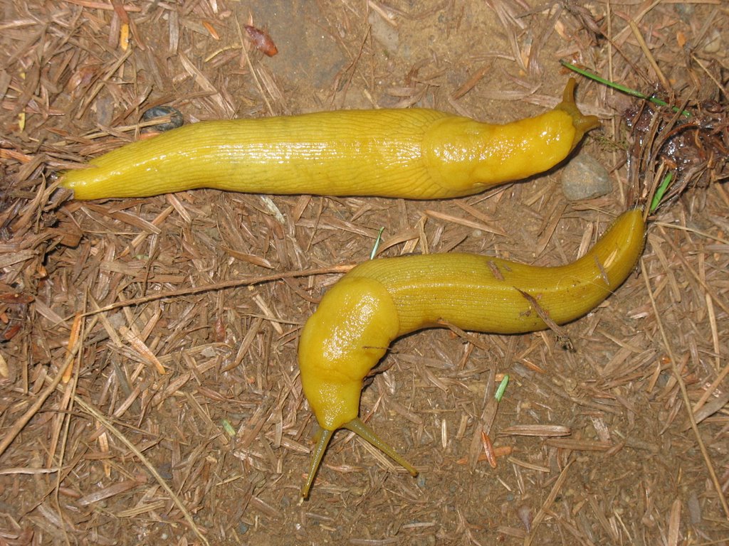
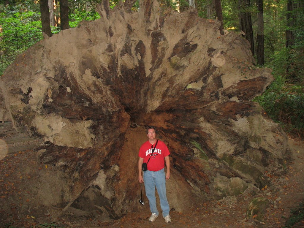
We start through the forest on cushy, level land, and we see the biggest clovers we’ve ever seen!
The intro tape we saw at the Visitor Center yesterday informed us that the pinecone from a redwood, the tallest tree in the world, is the size of an olive. Based on the how big the trees are, we think it should be about the size of a cow.

Further along the easy trail, I spot a red frog. He shyly hops into the big clover. Then I see another one! And Mark spies a newt! He blends in so well with the sticks.

The first three quarters of a mile lead through the forest, but then the trail drops steeply for nearly another mile before leveling out to prairie on the way to the coast. Just before the trail opens up to the beach, we pass some wild blackberry bushes. Mark enjoys several berries (which looked like luscious redwood pinecones) before following me out to the dunes. When he’d caught up, he asked if I were going to eat any. “I don’t like blackberries. I’d eat them if I were desperate, but I don’t like them.”

We walk out to the upper beach, and I sit to empty sand from my shoe. Mark hikes onto the crest of the dune, before it slopes off to the ocean. We didn’t see a person the whole hike down, yet two fishermen stand at the shoreline tossing their lines into the sea. Their truck is parked on the beach.

The fog obstructs our view out to sea so with not much to see, we turn back after a short rest.

Remembering how steep the trail is and having my stomach growl and hearing Mark’s exclamations when he popped a sweet, juicy berry, I decide I am near desperate. At the berry patch we select the plumpest blackberries within easy reach. Mark laments that we don’t have a bucket. As he picks berries from the bush, he sees a bright green, little frog that seems less shy than the red ones I saw in the forest.

To me, the berries are more texture than taste, but I make it up the trail and back to the car (and water) without complaint from a hungry tummy or a parched throat.

We stay in the park until early afternoon, sticking with easy trails since we're worn out from the climb up Ossagon Trail. At Elk Meadow we picnic and hike to a waterfall before returning to Oregon. Redwoods National Park is one of my favorites.


Saturday, October 14, 2006

Oregon Caves and California - Day 6

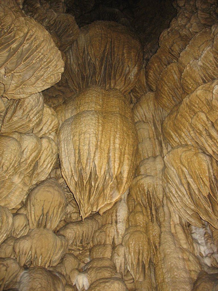
Mostly traveling today—with one stop on our way to Redwoods Forest National Park in California: Oregon Caves National Monument. We stopped at a market and bought batteries for the flashlight. We arrived at Oregon Caves in the early afternoon and registered for the cave tour and learned that flashlights were not permitted. All the way from Ohio for nothing.
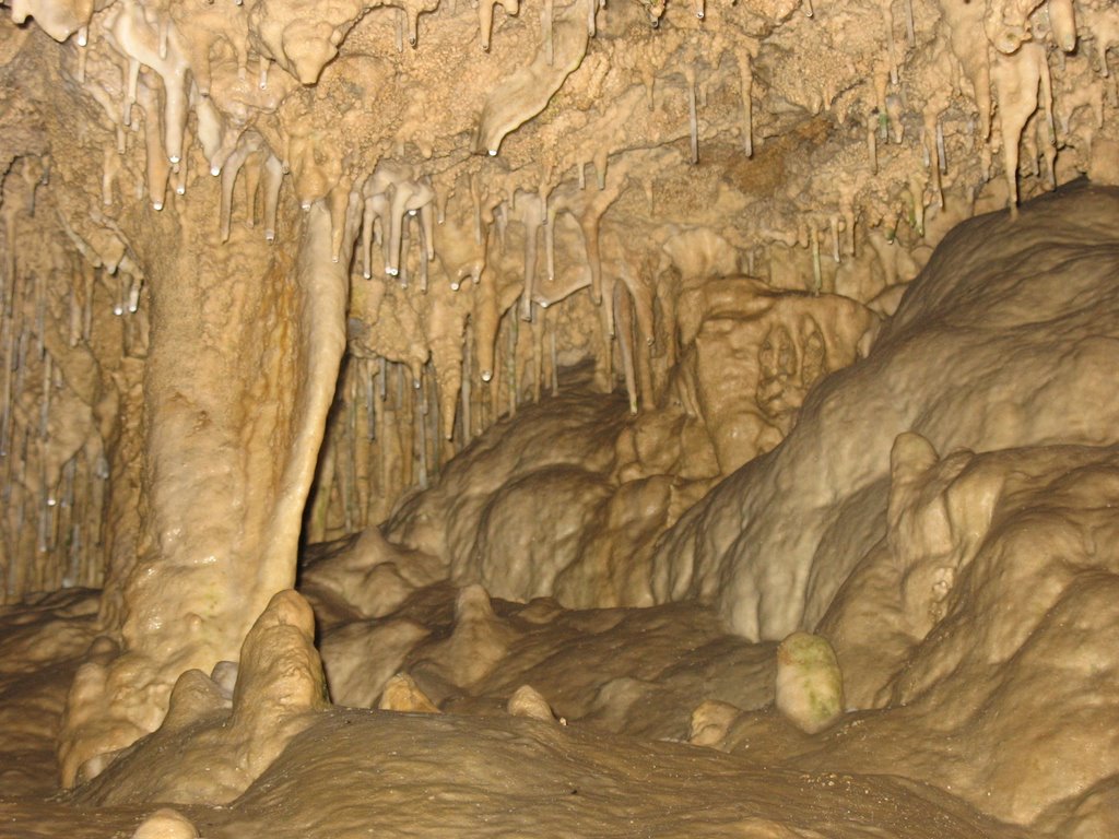
The cave was quite decorated, and inside we saw something we’d never seen before in all the caves we have traveled through: a tree root. The root was from a tree 55 feet above, and it stretched about 20 feet further along the cave floor.

Oregon Caves were discovered in 1874, by a young man hunting for bear, Elijah Davidson. Davidson found a bear, and his dog chased it into a whole on the side of a mountain. The love of a man for his dog led Davidson to follow though he could see nothing. He quickly gave up his pursuit and followed a gurgling, ice-cold stream out to safety. His dog was soon to follow, and Davidson set up camp at the cave’s exit, laying his provisions there to lure the bear. The following morning the bear made its way to daylight too, led by the scent of Davidson’s food. And BAM! Davidson shot himself a bear!

After 90 minutes the tour let out on the side of the mountain, and Mark and I continued up the trail—less than a mile—through the old growth forest—and then down again, back to the car. We grabbed our food and hiked a bit lower than the parking lot and picnicked in the forest.

On south to California. Our reservations were in Crescent City at the top tip of Redwoods National Forest. We entered California on a curvy, old logging road and so were pleasantly surprised to come across a Redwoods National Park Visitor Center, and we got there just 20 minutes or so before closing. The two rangers manning the VC seemed surprised and delighted to see us too. I’m not sure they had any visitors all the day up to that point. They told us that the VC would close for the season in a couple days; only the south VC would stay open. (Redwoods National Park runs along the California coast for about 100 miles.) One ranger helped me plan our visit for the next day. Then Mark and I watched the 12-minute introductory video and drove back to a hidden drive that the ranger turned us on to. Crescent City sat at the end of the seven-mile drive. We stopped for a short hike on our way; I took a picture of 6' 4" Mark at the bottom of an upended redwood.

After checking in to our motel, Mark and I drove down 101 to some lookouts over the ocean and then back to Anchor Way, which dead-ended at the water, and ate at a busy seafood restaurant, where we watched sea lions lazing in the cool evening air, some posing for pictures, quite used to the attention.

After dinner we drove to another bay and walked out to get a picture of the full moon, but it was chilly. Mark didn’t have a jacket, and he’s who took the picture so it’s all shaky. Turning the other way, we ran the length of the dock back to the warmth of our rental car. And from the car Mark got a really nice picture of a lighthouse backed by the lowest of sunsets.

Wednesday, October 11, 2006

Crater Lake – Day 5

Direct from my travel journal 5 Sept. 06

Crater Lake: no inlets to deposit sediment or silt – pure snow water. World record for clarity = 143’. Depth – 1943’. It’s so blue because it’s so deep. 6.1 mi X 4.7 mi. There are hydrothermal vents to support bacteria. Still active. Dormant for 5000yrs. Deepest lake entirely above sea level, 7th deepest in world. Deepest in US. 20.42 mi2, 4.9 trillion gal, 6173’ (1882m) above sea level – surface elevation. Surface temp 32 F – 66 F (0-19 C) 38 F (4 C) at bottom yr round. 44’ avg snow fall. From author Jack London, 1911, “I thought that I had gazed upon everything beautiful in nature as I have spent many yrs traveling thousands of miles to view the beauty spots of the earth, but I have reached the climax. Never again can I gaze upon the beauty spots of the earth and enjoy them as being the finest thing I have ever seen. Crater Lake is far above them all.” –

…We drove on to Crater Lake. The Visitor Center wasn’t open yet (not till 9 am) so we drove on to the rim village and walked around the rim. The view was better than yesterday. We’d gone just a little ways and taken about 5 pictures because it was so awe inspiring, when M. suggested we drive on up to Cleetwood Trailhead to get tickets to go on the boat ride to Wizard Island. [Wizard Island is the caldera/island in Crater Lake.]

We headed up the west side of the lake and saw a fleet of Nat’l Forest Fire control trucks lined up ready to go. We saw so much smoke to the west and traffic cones prevented parking in some areas. Further on, one pullout had fire info posted. The fire was started from a lightning strike July 23 so since it was natural, it was allowed to burn. It was only a smoldering fire to burn the brush and dead wood on the forest floor.

At Cleetwood ~9:25 and we were the last 2 to get on the 10 am boat tour - $59 for the both of us [meaning each]. We booked it down the mile-long trail and rode the boat 30 mins over to W.I. There we right away hiked up a mile to the top of the volcano to the caldera and we ate lunch while looking out to lake.

On the hike up we saw views of the lake that brought tears to my eyes, it was so beautiful.

The boat was to pick us up for our return at 12:30. We got down ~12:15. M went to dock, where others were hanging out, and I went to restrooms. Then I walked to a diff. dock, took my socks and boots off and put my feet in H2O-COLD! I was considering going skinny dipping, but it was too cold. I regret that I didn’t do it now tho. The boat got us ~12:45 and we toured other areas of the lake – Phantom Ship, 2 waterfalls, the Pumice Castle, and got back to Cleetwood at 2 pm.

Drove to Rim Village and went to gift store and bought post cards, a magnet and a necklace and then walked to a lookout, where a young ranger was giving a lecture.

After, we drove to the Pinnacles – like hoodoos a little bit w/ a stream running beneath. Even though the Pinnacles were at the end of a 7-mi drive, it was worth it. Back at the cabin we cleaned up and went to a Mexican Restaurant on 97 that the proprietor [of Crater Lake Resort] told us about yesterday. Yummy. We found it by the Big Yellow sign w/ black lettering: Mexican Food Cocktails.


From 6 Sept 06 journal entry

I didn’t consider Oregon “the West.” Yes, it’s true that OR is a westernmost state in the continental US, but I suppose I thought of OR more as Seattle, filled w/ tech Yuppies more so than w/ farmers and blue-collar types. In Mexican Food Cocktails last night we walked into a dark room w. square tables, straight-back chairs. There was some Latin art on the walls, but most of the ambiance was provided by the other customers – 5 locals, one of them a woman, all wearing hats. Our waitress wore Wranglers.

Friday, October 06, 2006

Newberry Volcanic National Monument and Crater Lake National Park – Day 4


After our fill of breakfast at Days Inn in Bend, we drove just south to Newberry Volcanic National Monument where we started a line to gain entrance to the park. At 9 a.m. the gate opened, we showed our National Parks Pass, and the ranger gave us a ticket to drive up to the caldera; the ticket gave us two hours. Because the caldera is so small, they have to monitor how many people go up at a time.

We were thinking the further south we went, the smoke from the forest fires near Mt. Hood would be less evident, yet a fire was ablaze in the Three Sisters/Mt. Bachelor area too, just southwest of Bend. So our view from the caldera, Lava Butte Lookout, was less than spectacular. But the short hike around the rim was nice. At the top friendly chipmunks begged for something to tuck away with their other winter supplies, but we heeded the warning not to feed the animals.
Back on level land, we entered the Visitor Center, I got hiking/touring advice for later, and we walked out back to the easy mile-long trail though the lava field. The top of Mt. Bachelor to the northwest peaked out of the settled smoke, yet the Three Sisters were still hidden. After the easy lava rock trail we took the easier tree trail bordering the parking lot and then drove the access road to Benham Falls. (One must first turn into the Newberry Volcanic National Monument from 97, and the road to Benham Falls is to the south before the entry gate to the NM.)

The day was beautiful, and the hike, along Deschutes River, was the prettiest, most pleasant hike I’ve ever taken. Locals fished from the banks, and plenty of tourists strolled the mile or so back to the falls, some rode bikes. Too bad smoke still hung on Mt. Bachelor, which we could see occasionally through a break in the trees. At one point I wanted to climb out on a rock on a cliff over the river and have Mark take my picture, but he said he didn’t want to encourage that type of activity so he wouldn’t do it and continued on. I climbed out anyway then climbed back and took a picture of the rock. I’ll tell people to imagine me on it. (Mark had the digital camera; I had the one with film—so no pic for the blog.)

Just before the falls, the running water was so loud, and we walked out to look up stream, and so powerful the water looked, roiling through the rock walls. I can’t imagine anyone surviving any kind of attempt to ride the rapids, whether in a vessel or not. Rough is the only way to describe it—besides beautiful and blue. I could have spent hours there, hiking down to the falls and back, enjoying the day and the calm, easy trail, however, we were on a schedule, hoping to get to Crater Lake National Park later today. So we drove south to the Lava Cave.

The tour was unescorted so Mark and I walked down to the entrance, declining the lantern rental since Mark brought a flashlight all the way from Ohio. In the mouth of the cave he discovered that the batteries barely had juice. So I trudged back up to the shack and rented a lantern to take with us.

I really enjoyed the cave. It’s the first I’ve been to without a guide, which in itself was kind of exciting. Most of the time it was just us and the latern. The temperature stays a chilly 42 degrees F throughout the year. We wore our Gortex jackets. At the entrance to the cave, the floor was rocky and uneven, like someone had dumped a truckload of petrified grapefruits, then it smoothed out in sandy bottom layers, like on a beach. We estimate to have walked a mile or so before the ceiling got too low for us to walk upright. After 100 yards or so walking in an uncomfortable, bent-over fashion, we chose to turn back.

Continuing with the lava theme, we drove further south to the Lava-Cast Forest and took an easy trail around the lava field and saw holes left where lava encased trees (and the trees are now gone). The holes reminded me of little kivas (Native American meeting places dug into the earth). On the trail we paused to look north to Mt. Bachelor, and even the Three Sisters were faintly evident through the thinning smoke.

Finally, we were on our way to Crater Lake, what we expected to be the highlight of the trip in the way of beauty. Surely the forest fires’ smoke wouldn’t reach that far south. Yet the nearer we got, the hazier the air became. We gained entrance with our Park Pass and drove south to Rim Drive and stopped there and climbed to a lookout. The caldera in which the lake sat was filled with smoke. We couldn’t see the blueness of the lake; it looked gray. We were disappointed.

We drove east around the lake, stopping frequently. The lake, even in all the smoke, was pretty and National-Park-worthy, we just expected so much more. Mark took a picture of the phantom ship, a tiny island that looks like a pirate ship.

The day was late, the air was smoky, and we had all the following day for the park, so we exited out the south and drove 25 miles east to Crater Lake resort, an RV park with about five cabins. We showered and went out to our little patio and ate the calzone, left over from dinner last night, while we watched three dogs from campers in the RV park familiarize themselves with the grounds and each other and while the mosquitos ate us up. Mosquitos in Oregon in September, Who knew?